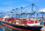
Imam Khomeini Seaport

The special economic zone of Imam Khomeini Port with an area of 11,044 hectares is located in the northwest of the Persian Gulf and at the end of Khor Musa waterway. This waterway with an average depth of 20 meters, a width of 250 meters and a length of 42 nautical miles has provided a calm and safe platform for the traffic of all types of commercial ocean-going vessels and oil tankers from the Persian Gulf, the Strait of Hormuz, the Sea of Oman and the Indian Ocean to all parts of the world. Due to the unique advantages of this port, such as proximity to 70% of important industrial and population centers of the country, proximity to Bandar Imam Petrochemical Special Economic Zone, proximity to Arvand Free Trade Zone, being on the route of North-South International Transport Corridor (INSTC) ) and the international transport corridor of East and West, being located in the shortest and most reliable land route for transporting goods from the countries of Iraq, Turkey, the Caucasus and Central Asia to the countries of Southeast Asia, turning this port into one of the most important commercial centers of Iran and the region has done. It has 36 km of internal main and secondary access roads and the operation of 140 km of internal railway to connect the port complex and supporting lands to the national railway network. The closest southern port to the population centers of the country, including Tehran, Isfahan, Alborz, Central and Qazvin provinces, a privileged geographical position, the most reliable, suitable and shortest communication bridge with the countries of the Caucasus, Iraq, Turkey and Eastern Europe, an effective role in the national economy and Foreign trade as the second most important port of the country with a 90-year history in providing port services, using expert manpower and the most advanced special port equipment and organizing it in the form of a fleet of land and sea equipment, the ability to provide services to all types of goods (container, grain , bulk, bagged, miscellaneous, petroleum materials, liquid oil, mineral and construction materials, industrial powders, etc.), an active wharf post with an average depth of 13.5 meters, having the facilities and exemptions of the Special Economic Zone of Imam Khomeini Port. Rah), the most suitable port in the country for the transshipment of goods to the northern countries of the Persian Gulf. Connection to the…
The special economic zone of Imam Khomeini Port with an area of 11,044 hectares is located in the northwest of the Persian Gulf and at the end of Khor Musa waterway. This waterway with an average depth of 20 meters, a width of 250 meters and a length of 42 nautical miles has provided a calm and safe platform for the traffic of all types of commercial ocean-going vessels and oil tankers from the Persian Gulf, the Strait of Hormuz, the Sea of Oman and the Indian Ocean to all parts of the world. Due to the unique advantages of this port, such as proximity to 70% of important industrial and population centers of the country, proximity to Bandar Imam Petrochemical Special Economic Zone, proximity to Arvand Free Trade Zone, being on the route of North-South International Transport Corridor (INSTC) ) and the international transport corridor of East and West, being located in the shortest and most reliable land route for transporting goods from the countries of Iraq, Turkey, the Caucasus and Central Asia to the countries of Southeast Asia, turning this port into one of the most important commercial centers of Iran and the region has done.
It has 36 km of internal main and secondary access roads and the operation of 140 km of internal railway to connect the port complex and supporting lands to the national railway network. The closest southern port to the population centers of the country, including Tehran, Isfahan, Alborz, Central and Qazvin provinces, a privileged geographical position, the most reliable, suitable and shortest communication bridge with the countries of the Caucasus, Iraq, Turkey and Eastern Europe, an effective role in the national economy and Foreign trade as the second most important port of the country with a 90-year history in providing port services, using expert manpower and the most advanced special port equipment and organizing it in the form of a fleet of land and sea equipment, the ability to provide services to all types of goods (container, grain , bulk, bagged, miscellaneous, petroleum materials, liquid oil, mineral and construction materials, industrial powders, etc.), an active wharf post with an average depth of 13.5 meters, having the facilities and exemptions of the Special Economic Zone of Imam Khomeini Port. Rah), the most suitable port in the country for the transshipment of goods to the northern countries of the Persian Gulf.
Connection to the country’s main transit roads and railway network, the largest port in the country in terms of the ability to store all types of goods such as dry and liquid bulk cargo, the ability to unload and load Post Panamax container ships (fourth generation) and ships with a capacity of 150 thousand tons, the existence of dedicated terminals for containers, general, petroleum products and minerals, benefiting from advanced and appropriate port and marine equipment in order to provide fast and safe services to ships, having the lowest cost of import-export goods in Between the ports of the country, using the integrated system (IMS) and the international information security system (SMS), having a single window system in order to provide centralized services to the customer.